Planning a trip to Scotland? You don’t need to carry paper maps, printed timetables, or guess when the tide will turn. The right apps can turn a stressful journey into a smooth adventure - whether you’re hiking the West Highland Way, catching a ferry to the Isles, or exploring Edinburgh on a rainy Tuesday. Here’s what actually works in 2026, based on real use by locals and travelers alike.
Offline Maps That Don’t Quit When You Lose Signal
Cell service vanishes fast in the Highlands. If you rely on Google Maps without a plan, you’ll be stuck staring at a spinning wheel near Glen Coe or on the A832 between Applecross and Kylesku. Offline maps aren’t optional - they’re essential.
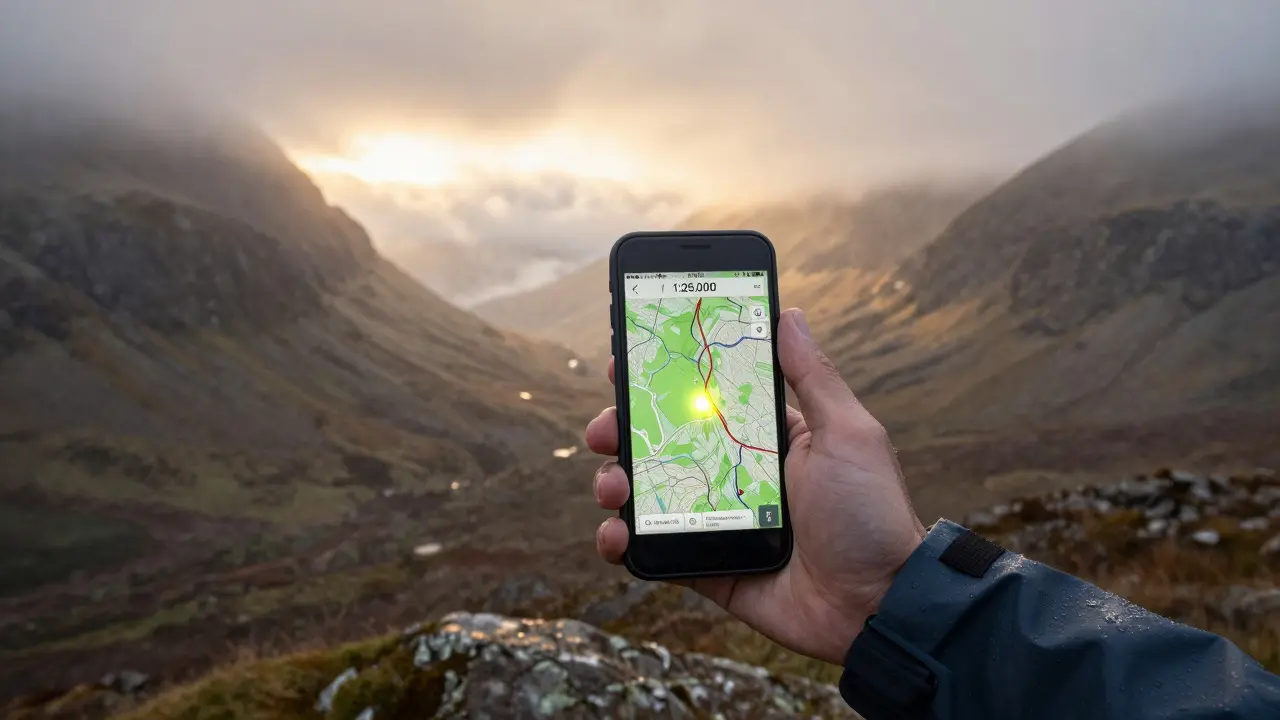
OS Maps is the official mapping app from Ordnance Survey, the UK’s national mapping agency. It offers 1:25,000 scale hiking maps, 1:50,000 road maps, and even historic overlays. Download entire regions like the Cairngorms or Skye before you leave Wi-Fi. The app works without data, shows real-time GPS tracking, and even has a ‘Find My Way’ feature that guides you back to your starting point. It’s not free - £3.99/month or £29.99/year - but if you hike or camp, it pays for itself on one trip.
For drivers, Waze is still useful for live traffic, accidents, and speed traps - but only if you’ve downloaded the region offline. It’s free and works well on major routes like the A9 or M8. Just don’t expect it to show footpaths or mountain trails.
Weather That Actually Predicts the Highlands
Scotland’s weather changes faster than a pub quiz answer. One minute it’s sunny at Loch Lomond; five minutes later, you’re in a misty downpour. Most weather apps fail here because they use generic models. You need one trained on local patterns.
Mountain Forecast is the go-to app for anyone heading into the hills. It gives detailed forecasts for over 1,000 Scottish summits - wind speed at 1,000m, temperature inversions, cloud base height, and snowfall accumulation. It updates every three hours and shows you exactly how conditions change with elevation. A hiker in Glencoe told me it saved his trip when the Met Office app said ‘partly cloudy’ but the mountain was socked in. It’s £4.99 one-time purchase.
For lowland travelers, Met Office app is surprisingly good. It’s free, official, and includes localized rain radar for towns like Inverness, Oban, and Stirling. It also has severe weather alerts - perfect if you’re driving the North Coast 500 in winter.
Tide Times That Actually Matter
Trying to walk across the sands of the Firth of Forth at low tide? Get it wrong, and you’re stranded. Same goes for visiting tidal islands like the Isle of May or exploring the tidal pools of the Moray Firth. You need accurate, location-specific tide data.
UK Tides is the simplest, most reliable app for this. It uses data from the UK Hydrographic Office and covers every port, beach, and estuary from Berwick-upon-Tweed to the Outer Hebrides. Tap a pin on the map, and it shows today’s high and low tides, plus the next 7 days. It even tells you the best time to collect shellfish or photograph the tidal causeway at Lindisfarne. Best part? It works offline. Free with optional £1.99 upgrade for tide charts and alerts.
Don’t use general tide apps like Tides Near Me - they often misplace your location. I once saw someone try to cross the tide at the Tay Estuary because the app listed ‘Dundee’ as 10 miles from the actual crossing point. Accuracy matters.

Train Times That Actually Update
ScotRail delays are legendary. So are the apps that don’t reflect them. If you’re relying on National Rail Enquiries or a static timetable, you’ll miss connections, especially on rural lines like the Kyle of Lochalsh or the Far North.
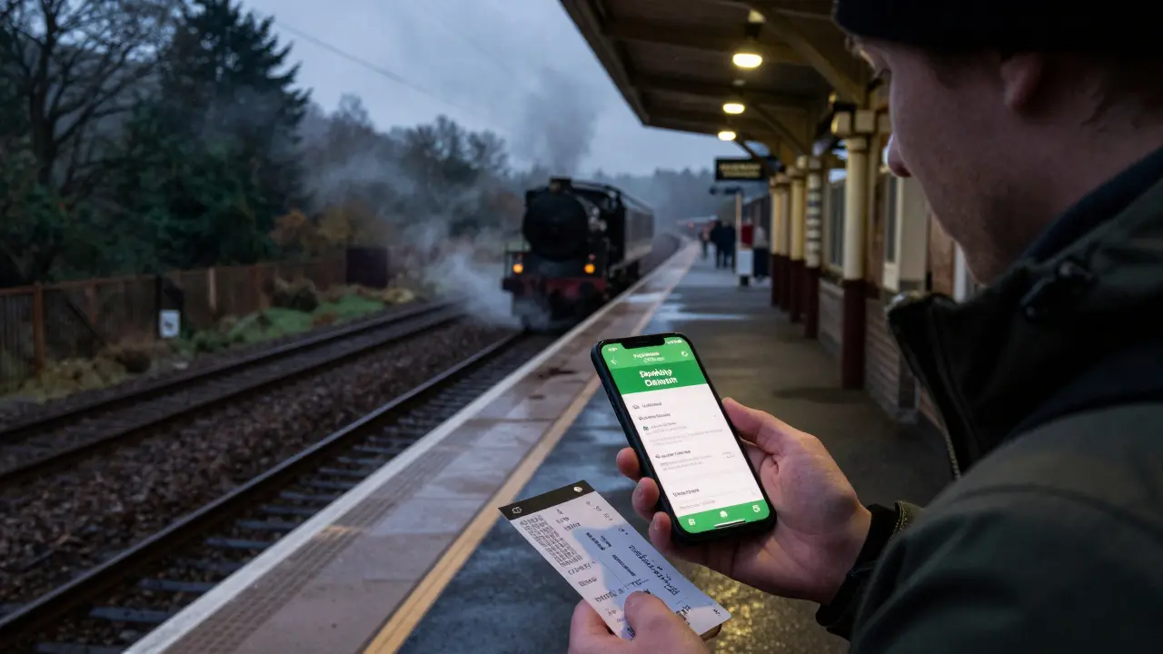
ScotRail App is the only app you need for trains in Scotland. It’s free, official, and updated in real time. It shows live departures, platform changes, delays, cancellations, and even service disruptions from weather or engineering works. You can buy tickets, check seat availability, and get alerts for your specific journey. I’ve used it to reroute from Inverness to Fort William after a landslip closed the line - all before the station staff knew about it.
For multi-operator trips (like connecting to Caledonian Sleeper or Northern Rail into England), use Trainline. It’s not Scottish, but it’s the most reliable aggregator for cross-border routes. It shows prices across operators, has offline ticket scanning, and sends SMS alerts if your train is delayed. The free version works fine - no need for the premium plan unless you’re booking 10+ trips a year.
What to Skip
Not every travel app works in Scotland. Avoid these:
- Google Maps for hiking - it doesn’t show footpaths, fences, or private land boundaries. Many trails in the Highlands are unmarked on Google.
- Weather.com - its Scottish forecasts are often outdated by 6 hours. The Met Office is always more accurate.
- Uber - it barely works outside Glasgow, Edinburgh, and Aberdeen. Rural areas rely on taxis booked via phone or local apps like MyTaxi.
- Wikipedia - it’s great for history, but it won’t tell you if the ferry to Mull is canceled due to high winds.
Build Your Toolkit
Here’s what to install before you leave:
- OS Maps - for hiking, walking, and off-road navigation
- Mountain Forecast - for high ground conditions
- UK Tides - for coastal trips and island visits
- ScotRail App - for all train travel
- Met Office - for general weather in towns
Turn on offline downloads for all of them. Charge your phone fully. Carry a portable power bank - you’ll need it. And if you’re going remote, tell someone your route. Apps help, but they don’t replace common sense.
Real-World Tip: The One App That Saved a Trip
Last October, a couple from London got caught in a sudden storm on the Isle of Skye. Their phone died. They had downloaded OS Maps and Mountain Forecast before leaving Edinburgh. They used the offline trail markers to find a sheltered path, checked the wind forecast on their backup tablet, and waited out the storm at a bothy near Sligachan. They didn’t get the photos they wanted - but they got home safe. That’s the power of the right tools.
Do I need to pay for all these apps?
No. OS Maps and Mountain Forecast are paid, but they’re worth it if you’re active outdoors. UK Tides and the ScotRail App are free. The Met Office app is free too. You can build a full toolkit without spending a penny - just download the free ones and use them offline.
Can I use these apps in the Outer Hebrides?
Yes, but only if you download the maps and data before you go. The Outer Hebrides have patchy mobile coverage. OS Maps, UK Tides, and ScotRail all work offline. Mountain Forecast works for Harris and Lewis summits. Just don’t rely on live data - plan ahead.
What if my phone dies?
Always carry a paper map for your main route - especially if you’re hiking. The Ordnance Survey Explorer series (sheets 341, 342, 343) are waterproof and detailed. For trains, print your ticket and note the departure times. Apps are tools, not lifelines.
Are there apps for ferries?
Caledonian MacBrayne (CalMac) has its own app with live ferry times, cancellations, and booking. It’s free and works offline. For smaller operators like the Orkney Ferries or the Tay Ferry, check their websites - many don’t have apps but post updates on Facebook.
Do these apps work in winter?
Yes - and they’re even more important in winter. Snow closes roads and trains. Wind cancels ferries. Mountain Forecast tells you if a pass is safe. OS Maps shows snow routes. ScotRail alerts you to delays. Don’t travel without them between November and March.
If you’re planning to explore Scotland’s wilder corners, your phone is your best companion - if you set it up right. These apps aren’t flashy. They don’t have influencers or filters. But they get the job done. And in Scotland, that’s what matters.
Comments (9)
-
Tonya Trottman March 7, 2026
Man, I spent three weeks hiking around the Cairngorms last year and I swear by OS Maps. I didn't have cell service for 90% of it, but that app kept me alive. The 1:25k scale is insane - you can see individual rocks and streams. I even used it to find a hidden bothy after getting caught in a sudden hailstorm. No fancy AI, no ads, just pure, beautiful topography. If you're serious about walking in Scotland, this isn't a luxury, it's a survival tool.
And yeah, Mountain Forecast? Absolute gold. I once ignored the Met Office app because it said 'light rain' - turned out there was a 15mph wind at 800m and visibility dropped to 2 meters. Mountain Forecast told me exactly that. I sat under a rock for two hours. Saved my trip. Don't be that guy who relies on generic weather.
Also, offline downloads. Do them. Even if you think you'll be fine. Scotland doesn't care about your plans.

-
Veera Mavalwala March 9, 2026
Y’all are acting like these apps are magic spells. Let me tell you about the time I tried to cross the Causeway at low tide using UK Tides - app said 10:17 AM low, but the water was already up to my knees at 9:45. Turns out the app was using the nearest tide station - 12 miles away. Accuracy? More like ‘hopeful guesswork.’
And don’t even get me started on ScotRail. I’ve had it tell me my train was ‘on time’ while standing on an empty platform for 47 minutes. The real ‘app’ is the guy in the station with a clipboard and a thermos. Apps are nice, but they’re not oracles. They’re just fancy spreadsheets with GPS.
Also, why is everyone ignoring the fact that half these apps require a subscription? You’re paying £30 a year to not get lost? That’s a rip-off. I’d rather carry a paper map and a compass. They don’t need Wi-Fi. Or batteries. Or a credit card.

-
Ray Htoo March 10, 2026
Just wanted to say - I love how this post doesn’t just list apps but explains why they matter. I’m a digital nomad who’s been bouncing between Lisbon and Edinburgh for a year now, and I’ve learned the hard way: Scotland doesn’t play nice with half-assed tech.
I used to think Google Maps was enough. Then I got stuck on the Bealach na Bà with no signal, no clue where the next turn was, and a rental car that kept beeping at me for ‘off-road violation.’ OS Maps saved me. I downloaded the whole Northwest Highlands the night before. The trail markers? Visible. The terrain? Accurate. The fact that it showed me a 300-year-old drover’s path I didn’t even know existed? That’s the kind of magic you can’t fake.
And yeah, the ScotRail app? I’ve used it to reroute three times. Once because a landslip took out the line near Fort William. The app pinged me 12 minutes before the station announcement. That’s efficiency. That’s reliability. That’s what you want when you’re trying to catch a ferry to Mull.
Also - portable power bank. Non-negotiable. I carry two. One for the phone, one for the tablet. And a solar charger. Because in the Highlands, the sun doesn’t care about your schedule.

-
Rocky Wyatt March 12, 2026
Wow. So you’re telling me that if I don’t pay for five different apps, I’m gonna die in the Scottish wilderness? Thanks for the guilt trip. I’ve been hiking in the Rockies for 20 years and never once needed a £30/year app to tell me where a rock was. You people are turning a trip into a tech audit.
And don’t get me started on ‘Mountain Forecast.’ You think a number on a screen tells you if a mountain’s gonna eat you? Nah. You need instinct. You need experience. You need to know when to turn back. Not when your phone says ‘wind at 1,000m is 23mph.’
I’ve got a compass, a thermos, and a sense of humor. That’s all you need. The rest is just corporate surveillance disguised as ‘adventure.’

-
Sheila Alston March 14, 2026
I’m sorry, but I have to say - this entire post feels like a sponsored ad. OS Maps? Mountain Forecast? UK Tides? All paid. And yet the article makes it sound like these are ‘essential tools’ like oxygen. Meanwhile, the local people I met in Oban were using free apps and paper maps. One man told me he’d been fishing the Moray Firth for 40 years and never once used an app. He said, ‘If you can’t read the sky and the sea, maybe you shouldn’t be out there.’
It’s not about technology. It’s about humility. And respect. And maybe… not monetizing every single corner of the natural world.
Also - why is there no mention of the Scottish Outdoor Access Code? You’re telling people to rely on apps to navigate, but the law says you have a right to roam. The apps are a crutch. The real tool is knowing how to behave.

-
sampa Karjee March 15, 2026
How quaint. You assume that because you downloaded an app, you now understand the landscape. How colonial. How bourgeois. The Scottish Highlands are not a theme park for tech-savvy tourists with Apple Watches and subscription-based navigation. The land does not exist to be mapped, tracked, or optimized for your Instagram story.
You speak of ‘offline maps’ as if they’re a noble innovation. But the real map - the one passed down through generations - is oral. It’s in the songs of the shepherds, the stories of the fishermen, the silence of the peat bogs. You think OS Maps is the pinnacle of human ingenuity? I pity you.
And yet - you still have the audacity to suggest that someone who doesn’t pay £29.99/year is somehow unprepared? The arrogance. The commodification of wilderness. The sheer, unvarnished neoliberalism of it all.
I’ve walked the West Highland Way without a single app. I carried a flask, a journal, and the memory of my grandfather’s voice. You? You carry a battery.
And you call that progress?

-
Santhosh Santhosh March 16, 2026
Let me tell you about the time I was in the Outer Hebrides and my phone died. I wasn’t scared. I wasn’t panicked. I just sat down on a rock, looked at the horizon, and listened. The wind, the gulls, the distant echo of a boat horn - that was my map. The tide charts? Useful. The weather forecasts? Helpful. But none of them replaced the quiet understanding that comes from being still.
I’ve used all the apps you mentioned. OS Maps saved me once. UK Tides helped me avoid getting stranded. But I’ve also used them as crutches - and that’s the real danger. We’ve turned navigation into a performance. We’re not exploring anymore. We’re checking boxes.
What I’ve learned in India, in Nepal, in Scotland - the land doesn’t care how many apps you’ve downloaded. It cares if you’re respectful. If you leave no trace. If you listen. If you don’t treat a mountain like a GPS waypoint.
So yes - download the apps. Use them. But don’t let them replace your humanity. The real tool isn’t in your pocket. It’s in your heart.

-
Natasha Madison March 18, 2026
Let me guess - all these apps are secretly controlled by the British government to track tourists and monitor their movements. I’ve read about this. They’re using the data to build a digital map of every hiker, every ferry rider, every coastal walker. Why? So they can restrict access later. ‘National security.’
And don’t tell me OS Maps is ‘official.’ That’s just a front. Ordnance Survey? That’s a British military mapping agency. They’ve been plotting the Highlands since the 1700s. They know every hidden cave, every abandoned bothy, every secret trail. And now they want you to pay for access?
Why not just carry a compass and a paper map? That’s what the real patriots do. Not these subscription-based, data-mining, corporate surveillance tools.
I’ve got a friend who went to Skye last year. His phone died. He didn’t panic. He just followed the sheep. And guess what? He found the trail. Because animals know the land better than any algorithm.

-
Patrick Sieber March 20, 2026
Just wanted to say - this is the most useful travel guide I’ve read in ages. No fluff. No sponsored nonsense. Just straight facts from someone who’s been there. I’m from Dublin, and I’ve done the NC500 twice. The first time, I relied on Google Maps. Got lost for six hours near Ullapool. The second time? OS Maps, Mountain Forecast, ScotRail, UK Tides. All downloaded offline. Zero issues.
And yeah - the Met Office app? Free. Accurate. Doesn’t try to upsell you. Perfect for when you’re in Inverness and need to know if you’ll need a jacket tomorrow.
One thing I’d add: always carry a backup power bank. Not the tiny one. The big, heavy one. I’ve got a 20,000mAh one that charges my phone twice. And I keep it in my jacket pocket, not my backpack. Cold kills batteries. Don’t let your phone die because you were too lazy to pack right.
Also - tell someone your route. Not just ‘I’m going to Skye.’ Say ‘I’m hiking from Sligachan to the Old Man of Storr, leaving at 7 AM, back by 4.’ That’s how you stay safe.
App recommendations? Spot on. Thanks for keeping it real.
