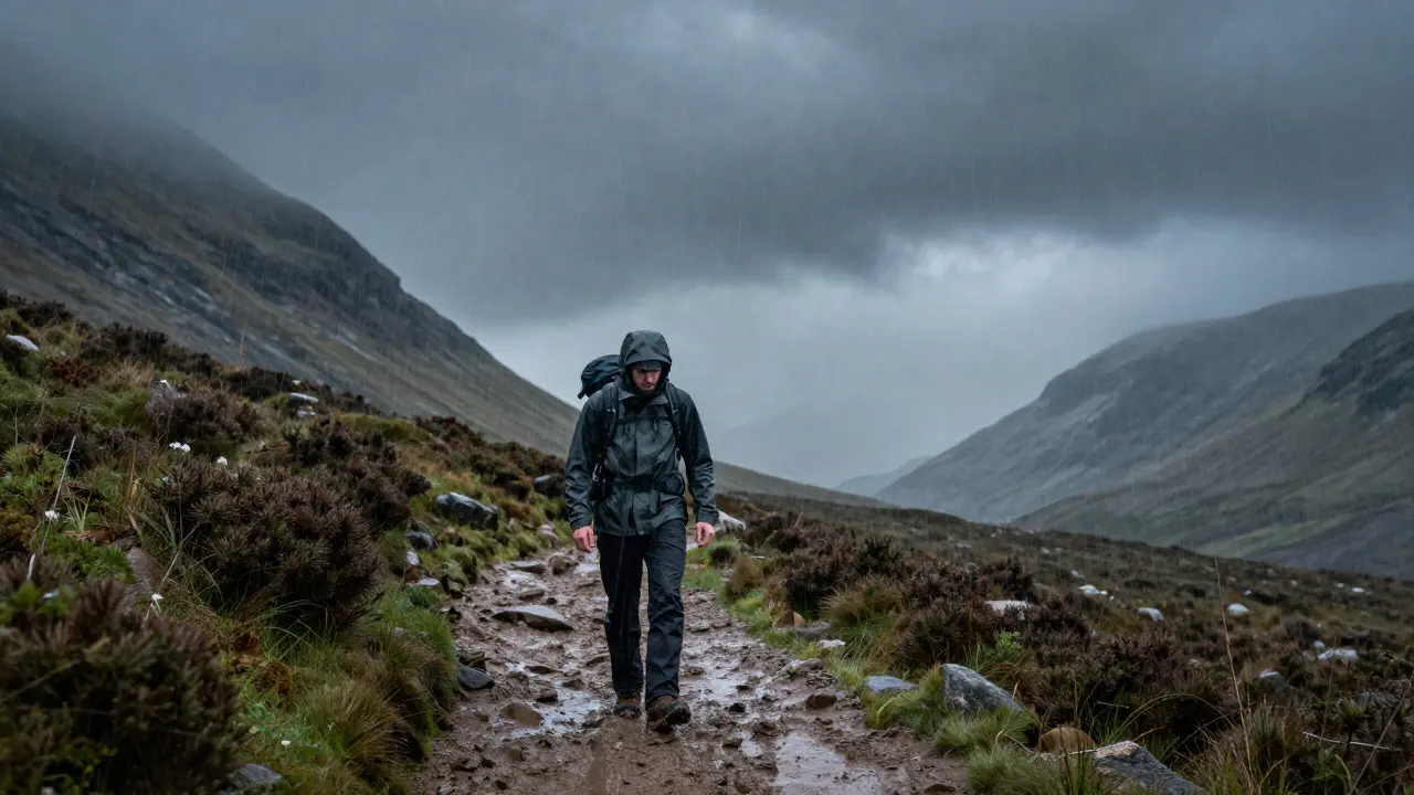
The wind hits you first. It doesn't ask permission; it just shoves against your chest while rain stings your eyes sideways. You are three miles into a glen that looked flat on your phone screen but is now a steep, muddy scramble. Your battery dies. The sky turns the color of bruised iron. This isn't a movie scene. It is a Tuesday afternoon in the Scottish Highlands, and if you aren't ready for it, you become a statistic.
Most people treat a hike in Scotland like a walk in the park. They don't. The terrain here is unforgiving, the weather changes faster than a politician's promise, and the silence can be deafening when you realize you've lost the trail. I live in Dundee, just south of the mountains, and I watch too many weekends end with search parties combing the heather because someone forgot a map or thought a fleece was enough for a summit push. Let’s fix that before you step off the pavement.
Reading the Sky: Why Scottish Weather Lies to You
You cannot predict the weather in the Highlands by looking at the sun on the valley floor. That sunshine is a trap. In the mountains, microclimates rule. One side of a ridge might be baking in UV rays while the other is buried in whiteout conditions. The key isn't forecasting; it's preparation for the worst-case scenario, every single time.
Temperatures drop roughly one degree Celsius for every 100 meters you climb. If it’s 15°C in Aviemore, it’s likely 5°C or colder at the top of Ben Nevis. Add wind chill, and that feels like freezing. Rain here isn't a drizzle; it's horizontal water that soaks through cotton shirts in minutes. Cotton kills. It loses insulation when wet and takes forever to dry. Wear synthetic fabrics or wool. Merino wool, specifically, retains warmth even when soaked and doesn't smell after two days of use.
Check the Mountain Weather Information Service (MWIS) before you go. Don't rely on generic apps that give you town-level data. You need forecast models for specific peaks. If the forecast says "showers," pack for a storm. If it says "windy," prepare for gale-force gusts that can knock you off balance on exposed ridges.
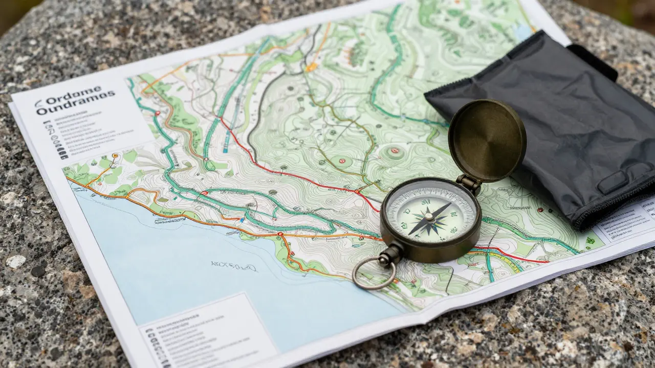
Navigating Without Signal: Maps and Compasses
Your phone is a luxury item in the Highlands, not a navigation tool. Signal bars vanish the moment you cross a watershed. Relying on GPS alone is dangerous because batteries drain fast in cold weather, and screens crack when you fall on granite.
You need an Ordnance Survey (OS) Landranger map. These are detailed, waterproof-friendly paper maps that show contour lines, paths, and landmarks. Learn to read them. Contour lines tell you the shape of the land. Close lines mean steep slopes. Wide gaps mean gentle gradients. If you can't match the map to the view in front of you, stop. Do not guess.
A baseplate compass is non-negotiable. It costs less than £10 and saves lives. Learn how to take a bearing. Align the map north with the compass needle, then follow the line. Practice this in your local park before heading to Cairngorms. When fog rolls in-and it will-your ability to navigate by feel becomes useless. Your compass points true north regardless of visibility.
| Tool | Reliability in Fog | Battery Dependency | Skill Required |
|---|---|---|---|
| OS Paper Map | High | None | Medium |
| Baseplate Compass | High | None | Low-Medium |
| Smartphone GPS | Low (Signal issues) | High | Low |
| Dedicated GPS Unit | Medium | Medium | Medium |
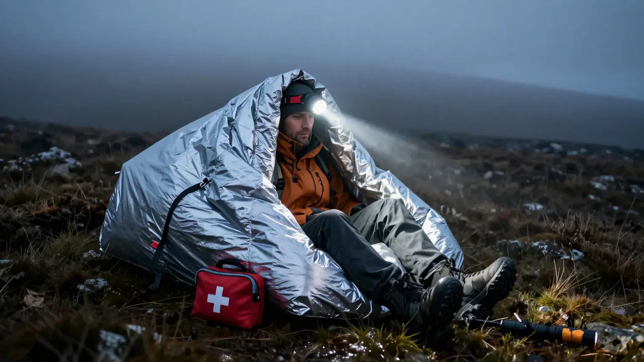
The Emergency Kit: What Actually Matters
Mountaineering Rescue teams across Scotland carry out hundreds of rescues annually. A significant portion of these involve hikers who got lost due to poor navigation or became hypothermic because they lacked proper gear. You don't need to carry a backpack full of survival gadgets. You need specific items that address the core risks: exposure, injury, and communication failure.
Here is the bare minimum for any day hike above 500 meters:
- Emergency Bivy Sack: A thin, silver-lined plastic bag. If you break your ankle and night falls, this reflects body heat and keeps wind/rain out. It weighs nothing and fits in a pocket.
- Headtorch with Spare Batteries: Even if you plan to finish by noon, delays happen. Walking in the dark without light is a recipe for broken bones. LED torches last longer than bulbs.
- First Aid Kit: Include blister plasters (Compeed), antiseptic wipes, and painkillers. Blisters turn easy hikes into nightmares.
- Whistle: Three sharp blasts are the universal distress signal. Sound travels farther than voice, especially in wind.
- Waterproof Jacket and Trousers: Not just a splash-proof windbreaker. Look for Gore-Tex or similar breathable membranes. You sweat when climbing; you freeze when stopping. Ventilation zips are crucial.
- Extra Food and Water: Carry more than you think you need. Energy bars, nuts, chocolate. Dehydration sets in quickly at altitude. Drink before you're thirsty.
Planning Your Route: The Leave No Trace Principle
Before you lace up, tell someone where you are going. Write down your planned route, expected return time, and vehicle registration number. Leave this note with a friend or family member. If you don't return by the stated time, they call Mountain Rescue. This simple step narrows the search area from hundreds of square miles to a few kilometers.
Use the 'Leave No Trace' principles. Pack out all trash, including fruit peels and toilet paper. Use designated campsites if staying overnight. Avoid trampling fragile vegetation like moss campion, which can take decades to recover. Stick to established paths where possible to prevent erosion. The Highlands are beautiful because they are wild, not because they are manicured. Respect that.
When Things Go Wrong: Immediate Actions
If you get lost, stop. Panic leads to bad decisions. Sit down. Drink some water. Eat something. Check your map and compass. Can you identify any landmarks? If not, stay put. Moving blindly increases the risk of injury and makes you harder to find. Rescue teams prefer stationary victims over moving ones.
If you are injured, assess the severity. Sprained ankles can often be supported with trekking poles or improvised splints. Broken bones require immobilization. Use your whistle every few minutes to alert rescuers. Keep warm. Hypothermia is the silent killer. Wrap yourself in your bivy sack, eat high-energy food, and keep moving slightly to generate heat if possible.
In an emergency, dial 999 and ask for Police, then ask for Mountain Rescue. Provide your exact location if known, or the nearest landmark. Describe your group size and injuries clearly. Stay on the line until the operator hangs up.
Choosing the Right Gear for Your Skill Level
Not every hiker needs technical climbing equipment. For most Munro baggers (those hiking peaks over 3,000 feet), sturdy boots, good layers, and reliable navigation tools suffice. However, if you plan to traverse rocky ridges like the Camster Ridge or winter hills, crampons and ice axes become essential. Hire a guide if you lack experience. Organizations like the Mountaineering Scotland offer courses that teach self-arrest techniques and crevasse rescue.
Invest in quality footwear. Cheap trainers slip on wet slate. Boots with Vibram soles provide grip on mud and rock. Break them in before a long hike. Blistered feet ruin trips faster than bad weather.
Do I really need a compass if I have a smartphone?
Yes. Smartphones lose signal in remote valleys and drain battery quickly in cold weather. A compass works indefinitely without power and provides reliable direction when visibility drops. It is a critical backup that costs very little.
What is the best clothing material for Highland hikes?
Avoid cotton entirely. Use merino wool for base layers as it insulates when wet and resists odors. Synthetic materials like polyester are excellent for mid-layers and quick-drying properties. Outer layers should be waterproof and breathable, such as Gore-Tex.
How do I contact Mountain Rescue in Scotland?
Dial 999 and request the Police. Then ask specifically for Mountain Rescue. Provide your location, group size, nature of emergency, and any medical conditions. Do not hang up until instructed. Volunteers respond rapidly but need accurate information to locate you safely.
Is it safe to hike the Highlands alone?
Solo hiking carries higher risks. If you choose to go alone, always leave a detailed trip plan with a trusted contact. Set strict turnaround times. Consider carrying a personal locator beacon (PLB) for emergencies where mobile phones fail. Group hiking is generally safer and more enjoyable.
What maps should I buy for Scottish hillwalking?
Ordnance Survey (OS) Landranger series maps are ideal for general hiking, offering 1:50,000 scale detail. For more technical routes or larger areas, OS Explorer maps (1:25,000) provide greater precision. Ensure you have the correct sheet for your destination, as coverage varies across regions.